


Le Pont de l Aille

MERMOZ33
User
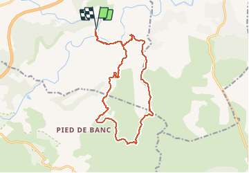

Length
17.8 km

Max alt
346 m

Uphill gradient
481 m
Km-Effort
24 km

Min alt
30 m

Downhill gradient
481 m
Boucle
Yes
Creation date :
2021-05-04 07:24:00.447
Updated on :
2021-05-04 13:52:06.068
6h26
Difficulty : Very difficult

FREE GPS app for hiking
 SityTrail
IGN / Geographical institutes
SityTrail Plus
The world is yours!
About
Trail Walking of 17.8 km to be discovered at Provence-Alpes-Côte d'Azur, Var, Les Arcs-sur-Argens. This trail is proposed by MERMOZ33.
Description
super
Positioning
Country:
France
Region :
Provence-Alpes-Côte d'Azur
Department/Province :
Var
Municipality :
Les Arcs-sur-Argens
Location:
Unknown
Start:(Dec)
Start:(UTM)
298517 ; 4812065 (32T) N.
Comments